
ISSN: 3005-8198 (online) | 3005-818X (print)
Volume 2, Issue 4 (October - December 2024) Pages 17-33
1 Department of Civil Engineering, Faculty of Engineering, University of Omar Al-Mukhtar, Al-Bayda, Libya.
2 Department of Civil Engineering, Faculty of Engineering, University of Tripoli, Tripoli, Libya.
Floods are among the most devastating natural hazards, increasingly intensified by climate change, rapid urbanization, and fragile governance systems. The Derna disaster in Libya in September 2023, marked by the catastrophic collapse of two dams, highlighted the severe limitations of outdated structural defenses and the absence of complementary non-structural measures. This study analyzes international flood risk management (FRM) strategies in the Netherlands, the United Kingdom, Bangladesh, and Saudi Arabia, examining the evolution of each nation’s approach from substantial reliance on structural protections to the adoption of integrated frameworks that balance engineered infrastructure with policy, governance, and community preparedness. The paper draws from these diverse contexts to develop a comprehensive FRM framework for Libya, adapted to its unique hydrological and geological conditions. The proposed framework is structured around the World Meteorological Organization’s four-pillar early warning model—namely, risk knowledge, monitoring and forecasting, warning dissemination, and preparedness—while embedding governance reforms, financial sustainability, and community engagement. Methodologically, the research employs a comparative case study and synthesizes best practices into an integrated strategy tailored for Libya. The findings emphasize that effective flood risk management cannot be achieved through structural measures alone; rather, an adaptive, multi-stage approach combining infrastructure, policy, and societal readiness is necessary.
Keywords: Flood Risk Management; Structural and Non-Structural Measures; Early Warning Systems; Climate Resilience; Libya.
Floods represent a substantial global threat to human life and development. According to Rentschler et al. (2022), 1.81 billion people are exposed to significant flood risk, particularly in low- and middle-income countries. The escalating risks of flooding, compounded by climate change and urbanization, underscores the pressing need for effective flood risk management (FRM) strategies (Letsch et al., 2023; Tabari, 2020).
Conventionally, flood management has placed considerable emphasis on structural measures, which encompass large-scale engineered interventions conceived to regulate or impede the progression of floodwaters. Throughout the 20th century, infrastructure such as levees, dikes, embankments, floodwalls, reservoirs, and dams have been pivotal components of flood control policies in numerous countries (Klijn et al., 2018; Letsch et al., 2023; Silva et al., 2004). Furthermore, the implementation of structural projects has been observed to result in the disruption of natural hydrological processes. A case in point is the occurrence of increased siltation, higher runoff, and land subsidence behind the dikes in the aftermath of embankments in Bangladesh. This phenomenon, contrary to expectation, has been shown to exacerbate the risk of flooding over time (Letsch et al., 2023). Additionally, engineered infrastructure is susceptible to catastrophic failure, as evidenced by incidents such as levee breaches or dam overtopping. This phenomenon is further compounded by the substantial costs associated with its construction and maintenance, in addition to its profound ecological implications. These measures are designed to mitigate the likelihood of flooding by containing rivers or obstructing storm surges. It is evident that these measures have effectively mitigated numerous flood events and facilitated the establishment of human settlements and economic activities in previously flood-prone regions. However, exclusive reliance on structural defenses has well-documented limitations and unintended consequences. A well-documented concern is the “levee effect” (also known as the “safe development paradox”). This effect states that by reducing the frequency of moderate floods, robust defenses can encourage more intensive development in the protected floodplain. Consequently, when an extreme event exceeds or breaches the defenses, the resulting disaster can be even greater (Ferdous et al., 2020; Heezik, 2008; White, 1942). As White (1942) observed, “flood defences may reduce the probability of flooding, but at the same time incentivize society to invest in protected areas to such an extent that eventually flood disasters tend to grow bigger instead of smaller” (Klijn et al., 2018). This paradox was tragically illustrated in the September 2023 Derna flood in Libya, where the catastrophic collapse of two aging dams, following extreme rainfall, transformed a natural event into a human catastrophe precisely because long-standing structural protections had fostered a false sense of security and inadequate non-structural preparedness. The drawbacks associated with this phenomenon, which have been clearly demonstrated in Derna, underscore the critical need to explore solutions that extend beyond purely structural measures.
International efforts to standardize flood risk management have culminated in comprehensive frameworks, most notably the Integrated Early Warning System model promoted by the World Meteorological Organization and United Nations agencies (United Nations Office for Disaster Risk Reduction, 2006; World Meteorological Organization, 2010). This global framework is built upon four synergistic pillars: risk knowledge, which involves understanding hazards, vulnerabilities, and capacities; monitoring and forecasting, requiring robust data collection and predictive capabilities; warning dissemination and communication, ensuring timely and actionable alerts reach all stakeholders; and response capability and preparedness, fostering a culture of readiness at both institutional and community levels (Basher, 2006; Zschau & Küppers, 2003). This holistic approach provides a standardized yet adaptable foundation upon which national strategies can be developed, emphasizing that effective risk reduction hinges on the seamless integration of these components rather than on standalone technological solutions.
This paper analyzes FRM strategies in the Netherlands, the UK, Bangladesh, and Saudi Arabia, representing diverse flood challenges and developmental contexts. The study examined their evolution toward integrated approaches to identify transferable lessons. These lessons hold particular urgency for Libya, as evidenced by the storm Daniel 2023, which exemplifies the failure stemming from reliance on aging infrastructure and a lack of non-structural measures. Therefore, this paper proposes a comprehensive, integrated FRM strategy for Libya. The strategy emphasizes risk assessment, modernized infrastructure, early warnings, improved governance, and community engagement. The objective of this strategy is to build long-term resilience based on global best practices.
Levees, also referred to as dikes or embankments, are constructed parallel to rivers with the purpose of containing floodwaters (Figure 1). These measures are structural in nature and are designed to reduce the frequency of flooding in the designated area by augmenting the containment barriers. However, when utilized in isolation, these barriers do not entirely mitigate the risk of flooding. Extreme floods have the potential to overtop or breach levees, and prolonged reliance on these barriers may encourage intensive development within the protected floodplain. This may, in turn, exacerbate the consequences of rare failures, a phenomenon referred to as the “levee effect” (Ferdous et al., 2020; Heezik, 2008; White, 1942).
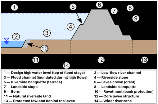
Figure 1. Structural Flood Protection – Example of a River Levee (File: River Levee Cross Section Figure.Svg – Wikimedia Commons, 2022).
Structural measures can be classified into two categories: flood control structures and storage/retention structures. The former include levees, floodwalls, and storm surge barriers, while the latter comprise dams, detention basins, and bypass channels. Their primary objective is to mitigate the risk of flooding in populated areas by either preventing the accumulation of water or relocating people to areas less susceptible to flooding. The effectiveness of structural interventions is typically quantified by a design standard, such as the design of a dike intended to contain a flood with a 1-in-100-year probability of occurring. Countries with advanced infrastructure frequently implement exceedingly high protection standards. For instance, the Netherlands has historically designed its dike rings to a 1-in-1,250 annual exceedance probability or better, reflecting the high stakes of flooding in a country where two-thirds of the land lies below sea level (Beck, 2012; Jongman et al., 2014; Silva et al., 2004). When meticulously engineered and meticulously maintained, structural defenses can significantly curtail the frequency of flooding, thereby enabling the development of major metropolitan areas and prosperous agricultural activities in floodplains that would otherwise be considered unfeasible. For instance, extensive dikes and storm surge barriers in the Netherlands and the Thames Barrier in London have been effective in protecting millions of people and billions in assets from frequent inundation.
Nevertheless, structural remedies are encumbered by substantial limitations. Firstly, these barriers can fail or be overtopped in extreme conditions, often resulting in catastrophic consequences due to the assumption of safety behind them (Der Most et al., 2014; White, 1942). Secondly, these measures have been observed to shift the location of risk rather than eradicating it. The construction of a levee in a particular riverine segment may result in the exacerbation of flood heights in downstream areas. Additionally, dams have been shown to give rise to concerns regarding the entrapment of sediment and the subsequent erosion downstream. Thirdly, the implementation of structural projects is often accompanied by significant expenses and extended periods of time. Furthermore, these projects necessitate continuous maintenance and periodic upgrades, a necessity that is particularly pronounced in the face of environmental pressures such as sea level rise or increased upstream runoff. Fourthly, the construction of hard defenses can have adverse environmental impacts, including the destruction of wetlands, alterations to river ecology, and subsidence due to disrupted sediment deposition (Letsch et al., 2023). Excessive reliance on structural measures has the potential to engender a false sense of security among residents, thereby reducing the motivation to insure property or to evacuate when necessary (Enning-Rowsell et al., 2004; Ferdous et al., 2020; Thorne, 2014). Consequently, experts have cautioned that flood risk management cannot be solely reliant on structural measures. An integrated approach is imperative for achieving long-term resilience (Chan et al., 2022; Grigg, 2024).
Completed in 2006, the Three Gorges Dam is the world’s largest dam (Figure 2). A primary objective of the project is to mitigate the risk of destructive floods, which have historically posed a threat to the densely populated downstream regions (Nasa Earth Observatory, 2009). The impounding of floodwaters in a 600-km reservoir serves to reduce the peak flows arriving downstream during the monsoon season, thereby reducing the intensity of flooding. Large multipurpose dams serve as a prime example of how structural measures can offer substantial benefits in terms of flood mitigation, in addition to their other functions, such as hydroelectric power generation and water supply. Many countries (e.g., China, the United States, India) have constructed extensive networks of reservoirs for the purpose of flood control. However, it should be noted that dams are not without their limitations. Their flood storage capacity is finite, and in the case of extreme floods, this capacity may be exceeded. Furthermore, the operation of dams necessitates a delicate balancing act between flood risk and competing uses. Moreover, the construction of the Three Gorges Dam resulted in significant social and environmental costs, including the displacement of over a million individuals and the submersion of vital ecosystems and cultural sites. Nonetheless, dams continue to serve as a fundamental component of structural flood management strategies in numerous basins, particularly in the context of regulating major river systems.

Figure 2. Satellite View of the Three Gorges Dam on the Yangtze River in China and its Reservoir (the Long Narrow Water Body Stretching Upstream) (Nasa Earth Observatory, 2009).
In contrast to structural approaches, non-structural measures aim to reduce the exposure and vulnerability of people and property to flooding, rather than stopping the floodwaters themselves (Figure 3). These measures are implemented through a systematic process involving planning, policy development, and preparedness. A non-exhaustive list of important non-structural tools includes: land-use planning and zoning, which are used to steer development away from high-risk flood zones or require elevation of buildings; building codes and retrofits (e.g., using flood-resistant materials, raising homes on stilts); flood forecasting and warning systems that provide advance notice to evacuate or protect valuables; community awareness and education on flood hazards and response (e.g., drills, school programs); emergency preparedness and evacuation planning by local authorities; financial mechanisms like insurance and catastrophe funds to spread and recover losses; and increasingly, nature-based solutions (sometimes classed as semi-structural) such as restoring wetlands to absorb floodwaters or reconnecting rivers to floodplains in a controlled way. Non-structural measures are frequently implemented to address the consequences of floods, with the objective of minimizing their impact when they do occur. These measures are often more sustainable in the long term. For instance, regulating floodplain development can prevent the creation of new risks, and early warning systems can be continually enhanced with technological advancements that are relatively inexpensive. Another benefit of the latter is flexibility, in that policies and preparedness can adapt quickly as risk patterns change, whereas concrete infrastructure is less nimble.
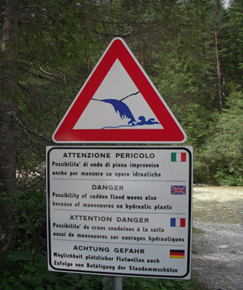
Figure 3. Non-Structural Approach – Flood Hazard Warning Sign (WIKIMEDIA COMMONS, 2012).
Figure 3 presents an illustration of a public warning sign in a flash-flood prone area (multiple languages: Italian, English, French, German) cautioning of the “possibility of sudden flood waves” due to hydraulic plant operations (File:Flood Warning.JPG – Wikimedia Commons, 2012). These measures, which include signage and alert systems, are non-structural in nature. Their purpose is to raise awareness and promote safety in areas susceptible to flooding. While these measures do not directly mitigate the physical risk of flooding, they play a crucial role in reducing the potential loss of life. For instance, by raising awareness about the risk of rapid water release from dams, they can encourage individuals to refrain from entering dry riverbeds during imminent flood events, thereby minimizing the risk of drowning. Public awareness campaigns, hazard signage, and community training are critical components of flood risk reduction, especially for flash floods that occur with little warning. In recent years, many countries have allocated significant resources to the development of modern flood forecasting and warning centers, with the objective of disseminating timely alerts to affected populations. For instance, the Flood Forecasting and Warning Centre of Bangladesh disseminates notifications regarding the levels of various rivers when they reach perilous levels. Additionally, Oman and other Middle Eastern nations are in the process of developing systems to alert the public of imminent flash floods (NASA Earth Observatory, 2022). The implementation of these measures necessitates the establishment of a robust communication infrastructure and the cultivation of community trust to ensure their efficacy. These measures have the potential to markedly reduce casualties by facilitating the timely evacuation of individuals and expediting the response of emergency services. Figure 4 provides a visual summary of structural and non-structural flood risk management measures, illustrating their complementary nature.
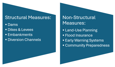
Figure 4. Structural vs Non-Structural Flood Risk Management Tools.
Despite the apparent distinctions between structural and non-structural approaches, there is no inherent incompatibility between them; in fact, they are most effective when used in combination. A levee system offers a fundamental level of protection, with additional layers of safety provided by flood warnings and land-use zoning ordinances, particularly in cases where the levee’s capacity is exceeded. This multifaceted approach is frequently referred to as a “multiple line of defense” or integrated flood management strategy. The ensuing case studies demonstrate how disparate regions have historically balanced these measures and how they are gradually converging towards integrated frameworks that incorporate the strengths of both. The experience of each nation provides a valuable source of insights. Europe has evolved towards a more comprehensive approach to flood risk management following centuries of confronting floods with barriers and dikes. Asia (Bangladesh) has acquired significant insights from disastrous floods, recognizing that structural projects alone are insufficient to mitigate the threat. The Middle East is only recently beginning to address floods as a growing hazard, adopting both new infrastructure and enhanced early-warning systems and planning strategies.
The Netherlands’ approach to flood management has evolved, transitioning from a reliance on substantial structural defenses to a more balanced strategy that integrates engineering, ecological considerations, and spatial planning. In the aftermath of the catastrophic 1953 North Sea flood, which resulted in the loss of over 1,800 lives, the nation constructed the Delta Works—a system of dams and storm surge barriers that is considered to be among the most advanced in the world (Klijn et al., 2018). Prior to the 1916 Zuiderzee flood and several medieval inundations, Dutch water management traditions had already been established. However, substantial evidence from major river floods in 1993 and 1995 demonstrated the limitations of even robust structures, thereby prompting the development of a novel strategy centered on adaptive and nature-based solutions (Klijn et al., 2013).
This initiative led to the establishment of the “Room for the River” program (2006-2015), which represented a strategic shift from a confrontational approach to a more harmonious coexistence with water. Rather than the continuous construction of dikes, the program’s approach entailed the creation of space for rivers to safely flood in designated areas. This was achieved through measures such as floodplain lowering, dike relocations, and the construction of secondary channels (Der Most et al., 2014). This approach acknowledges the potential for extreme events to exceed structural design thresholds and emphasizes adaptive capacity alongside engineered protection (Silva et al., 2004). The Dutch experience demonstrates that even highly advanced structural systems must be complemented with non-structural strategies that enhance systemic resilience. This is a crucial lesson for regions undergoing post-disaster reconstruction.
The United Kingdom’s approach to flood management has undergone a notable evolution, shifting from a primary focus on structural “defensive” measures to a more comprehensive, risk-based strategy. The occurrence of major floods in 1998 and 2000, particularly the widespread floods that occurred in the summer of 2007, exposed deficiencies in the existing systems and prompted substantial policy reviews (Cole, 2008). The United Kingdom has a long and storied history when it comes to severe flooding, with notable events including the 1947 Thames flood and the 1953 North Sea surge. These events resulted in the inundation of over 1,000 square kilometers of eastern England, leading to the construction of substantial large-scale defenses such as the Thames Barrier. These earlier events influenced the development of the country’s engineering-based protection systems, while the more recent floods highlighted governance and coordination deficiencies. Consequently, the government implemented the “Making Space for Water” strategy, which advocates for integrated management that aligns with natural processes rather than solely relying on structural measures (Thorne, 2014).
A fundamental aspect of the UK’s strategic approach involves the systematic incorporation of flood risk considerations into land-use planning through national planning policy (e.g., PPS25 and the National Planning Policy Framework). This policy mandates a sequential test to direct new development away from high-risk areas (Enning-Rowsell et al., 2004). Moreover, the establishment of the Flood Re insurance scheme in 2016 led to the development of a mechanism for affordable flood insurance, while concurrently promoting risk-based development decisions (Green, 2017). The United Kingdom’s experience highlights the critical importance of governance, policy instruments, and financial mechanisms as essential non-structural components that complement physical infrastructure in a comprehensive flood risk management framework.
Bangladesh’s flood management strategy has undergone a substantial evolution, transitioning from a predominant reliance on structural interventions to a more integrated approach that incorporates community-based adaptation measures. Early large-scale investments in embankments and polders, such as the Coastal Embankment Project, were initiated with the objective of mitigating the impact of floods and safeguarding agricultural activities. However, these endeavors frequently yielded unintended consequences, including waterlogging and siltation (Haque et al., 2019).
Bangladesh has learned from repeated major floods, including the devastating 1998 event, and has gradually strengthened its non-structural flood management measures. The country’s documented history of severe flooding, including events in 1974, 1987, and 1988, has resulted in significant loss of life and agricultural damage. This history has influenced the country’s approach to flood control and has garnered international support. These experiences demonstrated that even with extensive embankments, the delta’s complex hydrology necessitates adaptive management and robust community preparedness. Presently, the Flood Forecasting and Warning Centre (FFWC) disseminates pivotal early warnings, and a substantial network of multi-purpose cyclone shelters has considerably mitigated disaster-related fatalities (Haque et al., 2019). This transition towards a “living with floods” approach is exemplified by the Bangladesh Delta Plan 2100, which integrates structural protection measures with community resilience strategies, including adaptive agriculture and raised housing (Letsch et al., 2023). Bangladesh’s experience underscores the necessity of robust community-level preparedness and adaptive capacity in conjunction with structural investments.
Although large-scale floods have historically been rare in Saudi Arabia’s arid climate, archival and local records document several flash floods in Mecca (1941 and 1969) and Jeddah (1975), which caused recurring damage and loss of life. The accelerated expansion of urban areas since the 1990s has led to an escalation in surface runoff, resulting in the 2009 and 2011 Jeddah floods, which have been identified as the most destructive events in the country’s history and have played a pivotal role in the implementation of contemporary reforms in flood risk management. Consequently, Saudi Arabia’s strategic emphasis on flood management is a recent development, arising from the escalating threat of flash floods in densely populated urban regions. The catastrophic Jeddah floods of 2009 and 2011 exposed critical weaknesses in urban drainage and watershed systems, prompting major investments in new infrastructure and planning (Kotb et al., 2024). Figure 5 illustrates the substantial consequences of the 2009 flood, which resulted in pervasive infrastructure damage and significant vehicle destruction. This phenomenon underscores the vulnerability of rapidly developing urban centers to such hazards.
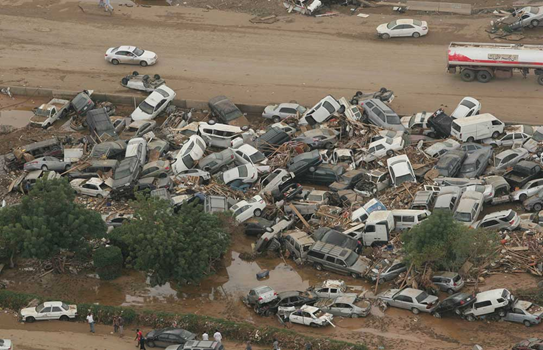
Figure 5. Aftermath of the 2009 Jeddah Flash Flood in Saudi Arabia.
The national response has entailed substantial investment in structural measures, including the construction of retention dams in key wadis, such as those proposed for Wadi Al-Lith, and the expansion of stormwater drainage networks in cities like Jeddah and Riyadh (Kotb et al., 2024). Concurrently, the country is developing its capabilities in flash flood forecasting, hazard mapping, and public awareness campaigns to address the rapid onset nature of the hazard. The experience of Saudi Arabia underscores the pressing need for rapidly developing arid nations to establish baseline structural defenses in parallel with the establishment of the non-structural pillars of early warning and risk-informed planning.
Libya’s flood risk profile encompasses multiple regions, with eastern coastal cities including Derna, Susa, Al Bayda, Shahat, Qandula, Al Werdiya, Al Bayada, and Al Marj experiencing catastrophic impacts during Storm Daniel in September 2023. Additional affected areas included Al Makhili, located south of Derna. Derna suffered the most severe consequences due to the collapse of two dams, resulting in an unprecedented loss of life and infrastructure. Susa also experienced extensive damage to urban infrastructure during the same event, highlighting the vulnerability of coastal cities to such extreme weather phenomena (Figure 6). The southern desert city of Ghat, located in proximity to the Algerian border, also experienced substantial flooding, thereby illustrating the national scope of vulnerability.
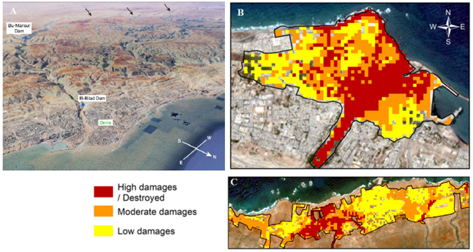
Figure 6. (A) 3D map of Derna Showing Flooding Caused by Extreme Rainfall and the Collapse of Two Dams; (B, C) Classification of Damage Severity Resulting from the flash flood in Derna and Susa (Hewson et al., 2024; Normand & Heggy, 2024).
The impending storm, designated as Daniel, had been anticipated several days in advance through the utilization of flood prediction models and had been extensively disseminated by various media outlets. In anticipation of the impending storm, national authorities implemented precautionary measures, initially focusing on Benghazi, as forecasts indicated that the Benghazi–Sirte corridor would be the epicenter of the storm. However, when the storm unexpectedly shifted eastward, striking the corridor between Al Marj and Derna, local emergency committees in Derna issued evacuation warnings. In the absence of an institutional framework integrating hydrologists and flood experts into the decision-making process, a critical misjudgment occurred. The authorities assumed that the primary risk was from the sea and ordered evacuations from coastal areas. Consequently, a significant number of residents relocated to higher ground within the city center, which was situated directly in the flood path of Wadi Derna. When the upstream dams failed, the redirected population faced catastrophic flooding, which resulted in amplified casualties and destruction. Despite efforts to revise evacuation strategies in the midst of the unfolding disaster, these measures were implemented too late, resulting in the event becoming the deadliest flood in Libya’s modern history.
The increasing frequency and intensity of such events in the context of climate change, in conjunction with the numerous aging dams across the country, perpetuate elevated flood risks throughout Libya. While the impact of Storm Daniel was predominantly felt in eastern regions, significant threats to major urban centers were also observed. In the city of Benghazi, the expansive Wadi Al Qattara watershed, along with its two primary dams (the primary and secondary Qattara dams), constitutes a considerable hazard to the western precincts of the city, particularly in the context of extreme precipitation events. A similar situation is observed in Tripoli, where the Wadi Al Majinin dam, situated south of the capital within a substantial watershed, poses a potential threat to the metropolitan area. In light of the accelerating rate of climate change, proactive measures are imperative to anticipate worst-case scenarios and implement appropriate preventive measures across all vulnerable regions.
In the aftermath of the 1970s, the Libyan state undertook the construction of eighteen dams, boasting a cumulative design capacity of 389.89 million cubic meters and an average annual storage capacity of 61.35 million cubic meters. This initiative was driven by the objective of enhancing water resources management and bolstering flood protection measures (Aqil et al., 2012). A thorough historical analysis reveals a considerable discrepancy between the designed capacity and the observed annual storage capacity of Libyan dams, including the Mansour Dam in Derna. Notably, the design capacity of the Mansour Dam exceeded the average storage capacity by tenfold, a factor that likely engendered a misguided sense of security regarding flood risk (Ashoor & Eladawy, 2024).
Despite the implementation of this infrastructure, the occurrence of flash floods in 1986 and 2011 exposed critical structural deficiencies in Libya’s flood protection systems, underscoring the pressing need for proactive preventive measures (Ashoor, 2024). The catastrophic events that transpired during Storm Daniel, culminating in the failure of the two dams in Derna, were not merely natural disasters but rather profound systemic failures. The city of Derna bore the brunt of the disaster, with the collapse resulting in thousands of fatalities and significant destruction of the city’s infrastructure. The sequence of events that culminated in this calamity was precipitated by a protracted period of oversight, characterized by the dilapidated condition of the dam infrastructure and substandard operational and maintenance practices. Moreover, there was a critical failure to act on recommendations from local and international experts regarding hydrological updates, which had predicted the precarious situation. It is imperative to note that essential measures, such as the addition of new spillways to accommodate the updated design flood and the construction of another crucial dam upstream from the Bumansour Dam to alleviate its load, were never implemented. This situation was further exacerbated by a paucity of administrative systems for disaster management and early warning, inadequate land-use planning that permitted development in high-risk zones, and an ineffective institutional coordination that was further compounded by prolonged conflict and state fragility. Consequently, the disaster in Derna was the result of this comprehensive multi-level breakdown (Ashoor & Eladawy, 2024).
In this context, the objective of this research is to develop a comprehensive national flood risk management strategy based on the integrated approach demonstrated by international experiences and the WMO Early Warning System framework. The proposed strategy necessitates a comprehensive re-evaluation of the hydrological regime, employing contemporary assessment tools across all vulnerable regions. Additionally, it calls for an exhaustive examination of local socio-economic contexts, with a particular focus on land ownership patterns and community engagement mechanisms. These factors have been historically disregarded in watershed management planning (Ashoor, 2022). This study proposes a multifaceted approach that integrates structural interventions guided by global best practices with non-structural measures that are aligned with the World Meteorological Organization’s (WMO) four pillars of risk knowledge, monitoring, dissemination, and response. The objective of this integrated approach is to develop a resilient framework tailored to Libya’s unique geographical and institutional context. The catastrophic failures that occurred in multiple cities during recent flood events exemplify the extreme vulnerability that arises from overreliance on decayed structural measures without complementary non-structural strategies. This validates the critical need for the integrated approach advanced in this research and the urgent implementation of an early warning system to minimize future damages.
This study employs a qualitative case study approach to develop a context-specific Flood Risk Management (FRM) framework for Libya, with a primary focus on the Derna region. The methodology is structured in three sequential phases, ensuring the proposed framework is grounded in both international best practices and local realities.
The initial phase entailed a systematic analysis of FRM strategies in four selected countries: the Netherlands, the United Kingdom, Bangladesh, and Saudi Arabia. The cases selected for this study were chosen to represent a diverse spectrum of flood challenges (riverine, coastal, monsoonal, and flash floods), economic capacities, and policy evolution stages. The analysis focused on the following:
This comparative analysis provides the foundational principles for the proposed framework, ensuring that it is informed by proven global experiences rather than being designed in isolation.
The proposed framework is rooted in the Integrated Early Warning System (EWS) model, a framework that has been promoted by both the World Meteorological Organization (WMO) and the United Nations. The selection of this model is predicated on its comprehensiveness and global recognition. The foundation of this initiative is rooted in four interwoven pillars:
The adaptation process involves customizing each pillar to the specific geographical, hydrological, and institutional conditions of Libya, particularly for flash flood scenarios prevalent in its coastal cities like Derna.
The final phase integrates the findings from Phase One and Phase Two to formulate the comprehensive FRM framework. This synthesis guarantees that the technical EWS model is supported by the requisite governance, financial, and community structures identified as critical success factors in the international review. Consequently, the framework encompasses more than a technical EWS, incorporating additional components.
This methodology ensures that the proposed strategy for Libya is not merely a technical blueprint but a holistic, sustainable, and adaptable system designed to build long-term resilience against flood risks. Figure 7 provides a synopsis of the methodological approach employed in this study.
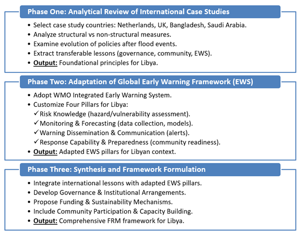
Figure 7. Methodological Framework of the Study, from Literature Review to Comparative Synthesis of Case Studies.
The four case studies—Netherlands, UK, Bangladesh, and Saudi Arabia—offer a rich comparative perspective on flood risk management strategies. The differences between these regions are evident in a variety of aspects, including but not limited to climate, flood typology (temperate river deltas vs. tropical monsoonal plains vs. arid flash floods), economic capacity, and historical experience. Despite these differences, some common themes emerge, underscoring the interconnected nature of these environmental phenomena. Table 1 provides a synopsis of structural, non-structural, governance, and community preparedness measures in each country. Figure 8 provides a visual synthesis of the relative strengths across the four dimensions, allowing for a clearer comparison at a glance.
| Table 1. Comparative Highlights of Flood Risk Management Strategies Across Case Studies. | ||||
|---|---|---|---|---|
| Country (Region) | Structural Measures | Non-Structural Measures | Governance | Community Preparedness |
| Netherlands | Advanced dikes, storm surge barriers, “Room for the River” | Spatial planning, EU directives | Strong water boards, long history | Moderate; reliance on defenses reduces preparedness |
| United Kingdom | Thames Barrier, levees, coastal defenses | “Making Space for Water,” SuDS, insurance | Clear policies, coordinated agencies | Community flood wardens, awareness programs |
| Bangladesh | Embankments, polders, drainage | Early warning systems, land-use rules | Improving, reliant on aid | Strong; cyclone shelters, grassroots adaptation |
| Saudi Arabia | Dams, flood drainage in Jeddah & Riyadh | Mapping, warning systems in development | Institutions still evolving | Limited; awareness growing after 2009 floods |
| Libya (Derna) | Aging dams, inadequate drainage | Virtually absent early warning system | Weak institutional coordination, fragmented | Minimal; limited public awareness |
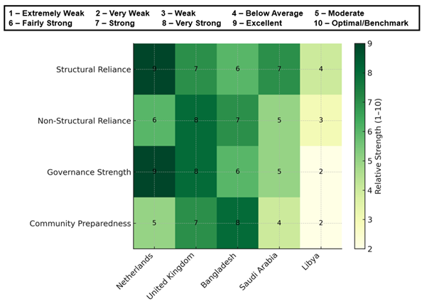
Figure 8. Comparative Analysis of Flood Risk Managements Strategies.
The analysis demonstrates that an integrated approach combining structural and non-structural measures is essential for comprehensive flood protection (Chan et al., 2022). This principle is reflected across all cases: the Netherlands and the UK have integrated spatial planning into engineering approaches, Bangladesh combines embankments with community-based warning systems, and Saudi Arabia is complementing drainage infrastructure with emerging alert systems. It is crucial to note that each country’s strategy reflects contextual adaptation, with measures tailored to local conditions, resources, and flood typologies. Examples of this adaptation include the Netherlands’ high-investment structural protections and Bangladesh’s community-focused adaptations (Letsch et al., 2023).
Effective governance and community engagement prove to be of equal importance as technical solutions. The United Kingdom’s policy reforms (Defra, 2010), Bangladesh’s stakeholder partnerships (Haque et al., 2019), and the Netherlands’ decentralized water boards illustrate that institutional capacity is a fundamental element for successful implementation. Moreover, climate adaptation necessitates forward-looking planning, as evidenced by the Netherlands’ Delta Programme and the UK’s Thames Estuary 2100 project (Grigg, 2024; Klijn et al., 2018). For Libya, these lessons dictate a dual approach: addressing immediate structural safety while building non-structural capacity through early warning systems, governance reforms, and community engagement—the integrated strategy this research advocates.
The proposed operational framework for Libya’s Integrated Flood Early Warning System, illustrated in Figure 9, is based on an international comparative analysis and is aligned with World Meteorological Organization (WMO) standards. This framework follows a systematic sequence that integrates the four WMO pillars with risk reduction measures. The framework commences with a comprehensive risk assessment, establishing the foundational stage during which topographical and hydrological studies identify vulnerable areas and critical infrastructure. The initial phase of this study employs Geographic Information System (GIS) technology to develop detailed flood hazard maps for various rainfall scenarios. These maps incorporate climate change projections and lessons from Storm Daniel’s impact analysis.
The monitoring and forecasting component is predicated on this knowledge base, and its technical infrastructure comprises strategic networks of rain gauges and water level sensors positioned near wadi watersheds. These stations facilitate the transmission of real-time data through dependable communication systems to central control centers, thereby enabling the operation of hydrological models such as GIS, HEC-HMS, HEC-RAS, and others. This predictive capability enables the calculation of runoff volumes and the forecasting of flood levels and arrival times at specific urban locations when rainfall exceeds predetermined thresholds.
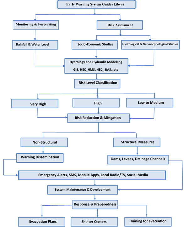
Figure 9. An Integrated Flood Management Framework for Libya: Derived from Comparative Analysis and WMO Guidelines.
The monitoring and forecasting component is predicated on this knowledge base, and its technical infrastructure comprises strategic networks of rain gauges and water level sensors positioned near wadi watersheds. These stations facilitate the transmission of real-time data through dependable communication systems to central control centers, thereby enabling the operation of hydrological models such as GIS, HEC-HMS, HEC-RAS, and others. This predictive capability enables the calculation of runoff volumes and the forecasting of flood levels and arrival times at specific urban locations when rainfall exceeds predetermined thresholds.
Subsequently, the system transitions to risk reduction measures, which integrate structural and non-structural approaches. Structural interventions are defined as the implementation of infrastructure designed to regulate water flow and manage excess water in urban areas. Such interventions may include the construction of dams that function as upstream reservoirs, the installation of linear water barriers along riverbanks, and the creation of engineered drainage channels. The primary objective of these structural interventions is to regulate flow and effectively divert excess water from urban areas, thereby mitigating potential flooding and maintaining safe and manageable levels of water in the environment. These measures are further augmented by non-structural emergency procedures, which, when implemented effectively, contribute to enhancing the overall resilience of the system. The efficacy of these non-structural emergency procedures is contingent upon meticulous maintenance, climate- and environmentally adaptive design, and integration with complementary measures.
The dissemination of warnings and subsequent communication represents a critical nexus between technical systems and public safety. Emergency operations centers receive and analyze forecasting data, activating multi-channel alert systems including sirens, SMS broadcasts, mobile applications, and media partnerships. The system utilizes a clear warning gradient with defined levels (Advisory, Watch, Emergency Evacuation) to communicate appropriate response actions based on threat severity.
The final component emphasizes response preparedness and institutional coordination. In this regard, detailed evacuation plans, clear role definitions, and regular training exercises ensure effective emergency management. Procedural maps delineate the evacuation routes and shelter locations, while maintenance protocols ensure the reliability of the system. This comprehensive framework establishes a continuous cycle of enhancement, wherein post-event evaluations contribute to ongoing refinements to risk assessments, monitoring capabilities, and response strategies.
This integrated approach ensures that data and information flow sequentially through system components, thereby enabling an organized and rapid response during flood events while establishing clear roles and responsibilities at each operational stage. The visual depiction in Figure 8 functions as a practical guide for decision-makers and a comprehensive illustration of how technical and institutional components interact to establish a resilient flood management system tailored to Libya’s specific challenges.
A comparative analysis of flood management strategies reveals that technical systems, while indispensable, are inadequate as a standalone solution. The success of these initiatives hinges upon the presence of robust enabling frameworks that facilitate governance, financing, community participation, and continuous evaluation. This principle is consistently evident across all the international case studies and is directly relevant to Libya’s proposed Integrated Flood Early Warning System.
A critical first enabling factor is governance and institutional design. The United Kingdom and the Netherlands offer case studies in this regard. The former has a clearly defined policy framework, while the latter has a decentralized water governance structure. These examples underscore the importance of clearly delineated roles and responsibilities. For Libya, this translates into the establishment of a National Disaster Risk Management Committee, which is empowered by legislation to coordinate ministries, municipalities, and local actors. Such an arrangement would overcome the institutional fragmentation observed in Saudi Arabia’s early flood management efforts, while aligning with the coordinated approaches that have proven successful in European contexts.
Financial sustainability is equally important. Bangladesh exemplifies the significance of diversified funding sources, while the United Kingdom’s Flood Re insurance mechanism demonstrates the potential of risk-sharing to augment state support. Libya has the potential to implement a phased financing strategy that integrates government budgets, international grants, public-private partnerships, and a dedicated disaster fund. This strategy aligns with the incremental investment models that enabled other nations to methodically develop, adapt, and refine their systems over time.
Community engagement has been identified as a significant enabler in this context. Bangladesh’s community-based model, which empowers local volunteers to disseminate early warnings, when combined with the Netherlands’ stakeholder engagement practices, offers a viable pathway for Libya to cultivate local ownership. Integrating awareness campaigns, participatory planning committees, and programs analogous to the UK’s flood wardens can strengthen trust in warning systems and enhance local response capacity elements that are often underestimated in initial system rollouts.
Finally, the system must be underpinned by continuous evaluation and adaptive learning. The Netherlands’ Delta Programme and the UK’s regular policy reviews illustrate how learning cycles can be institutionalized. For Libya, post-event assessments and periodic audits will facilitate the refinement of system operations, thereby ensuring that technical investments remain responsive to evolving risks and vulnerabilities.
The interplay of these enabling factors—governance, financing, community participation, and adaptive evaluation—establishes the framework that facilitates the transformation of technical infrastructure into a genuinely integrated and resilient system. By incorporating these lessons into its national strategy, Libya can circumvent the prevalent pitfall of establishing advanced technical systems that ultimately prove ineffective due to the absence of robust institutions. This ensures that its approach to flood risk management is effective in delivering enduring and pragmatic risk reduction.
Flood risk management, therefore, is a multifaceted endeavor aimed at facilitating coexistence with one of nature’s most recurrent and formidable hazards. This comparative study of strategies across Europe, Asia, and the Middle East has demonstrated that a uniform solution to the issue of flooding is lacking. On the contrary, optimal outcomes are derived from a combination of structural and non-structural measures, which are adapted to the specific local context and executed concurrently. The Netherlands’ implementation of advanced dikes and proactive floodplain restoration, Bangladesh’s establishment of community warning systems and the promotion of resilient livelihoods, the UK’s implementation of policy reforms, and the Middle East’s rapid infrastructure development exemplify the efficacy of learning and adaptation over time.
For Libya, the disastrous events in Derna and other coastal cities highlight the pressing necessity to transition from disparate interventions to a cohesive national strategy. The present study proposes a comprehensive framework that adapts international best practices and WMO standards to Libya’s specific hydrological, institutional, and social context. The proposed approach integrates structural safety measures with a robust early warning system, reinforced by effective governance and community engagement.
Several key lessons and recommendations emerge for Libya:
In order to achieve this objective, it is essential that engineers, planners, policymakers, and communities collaborate, integrating structural defenses with intelligent policies and preparedness measures to establish genuine flood resilience in Libya. Case studies from Europe, Asia, and the Middle East demonstrate that integrating hard infrastructure with adaptive, non-structural measures can significantly mitigate risk, safeguard lives and livelihoods, and foster sustainable coexistence with natural water systems. The present moment is optimal for the initiation of integrated action.
A.A: Conceptualization, Methodology, Formal analysis, Investigation, Writing of the original draft, Visualization.
H.A: Conceptualization, Methodology, Formal analysis, Investigation, Writing of the original draft, Writing – review & editing, Visualization, Supervision, Project administration.
The authors declare that they have no known competing financial interests or personal relationships that could have appeared to influence the work reported in this paper.
This research did not receive any specific grant from funding agencies in the public, commercial, or not-for-profit sectors.
The authors acknowledge that AI-based tools were used in a very limited manner, solely to refine the language and improve readability. All revisions made by these tools were carefully reviewed, verified, and further refined by the authors. They affirm that all conceptualization, methodology, analysis, and scientific interpretations were entirely developed by the authors themselves.
The data that support the findings of this study are available from the corresponding author upon reasonable request.
The authors declare that there is no acknowledgement to be made.
This study did not involve human participants or animals; hence, no ethical approval was required.
Cite: Ashoor, A., & Abdelgader, H. S. (2024). Risk management in Libya: Learning from Experiences from Europe, Asia, and the Middle East. Steps For Civil, Constructions and Environmental Engineering, 2(4), 17-33. https://doi.org/10.61706/sccee12011215
![]() Copyright: © 2024 by the authors. Licensee Scientific Steps International Publishing Services, Dubai, UAE.
Copyright: © 2024 by the authors. Licensee Scientific Steps International Publishing Services, Dubai, UAE.
This article is an open access article distributed under the terms and conditions of the Creative Commons Attribution (CC BY) license (https://creativecommons.org/licenses/by/4.0/).


An independent academic publisher with an editorial team including many of the top researchers in the world. SSG publishes research, review, and case report articles in double-blind, peer-reviewed, open access scientific and academic journals.
Copyright © 2025 Scientific Steps International Publishing Services LLC (Dubai – United Arab Emirates)